Areas closed to all hound hunting
For detailed information on Hound Hunting please read A Guide to the use of Hounds for Hunting Sambar Deer ![]() [PDF File - 10.3 MB] or visit the hound hunting page.
[PDF File - 10.3 MB] or visit the hound hunting page.
The hunting of Sambar Deer with scent-trailing hounds is prohibited in the areas indicated by shading in the maps below for Marysville, Warburton, Merrijig, Mount Timbertop and Jamieson-Kevington.
All forms of deer hunting (including hound hunting) are also prohibited in the areas indicated by shading in the other maps on the page.
The following maps have been developed to help hunters and the general public to identify the closed areas.
Maps
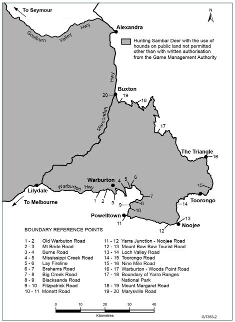
1. Area around Marysville, Warburton and surrounds closed to Sambar Deer hunting with hounds

2. Area around Jamieson-Kevington closed to Sambar Deer hunting with hounds
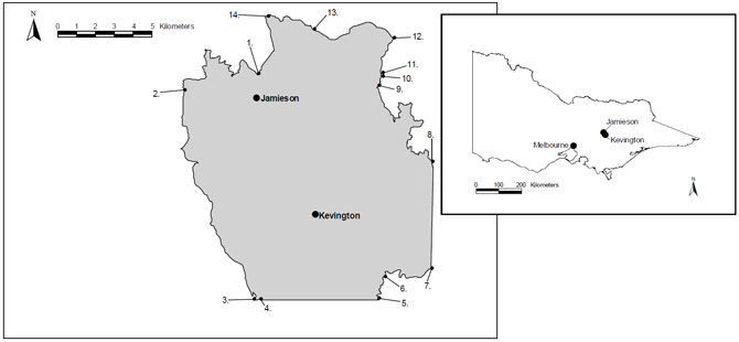
Image description: This image shows 2 maps. One map shows the Victorian state outline with Melbourne, Jamieson and Kevington marked. Jamieson is north east of Melbourne at a distance of about 160km. Kevington is about 5 km south east of Jamieson. The second and main map is of the boundary around Jamieson and Kevington. The boundary is roughly in the shape of a rectangle where the vertical axis (north/south) is longer than the horizontal axis (east/west). Jamieson is situated in the north west of the boundary and 5 km to the south east is Kevington. Boundary reference point is about one km north of Jamieson. Boundary reference points 2 to 14 are scattered around the boundary in an anti clockwise direction.
Boundary Reference Points
1-2 Elidon-Jamieson Road
2-3 Mount Terrible Track
3-4 Newmans Track
4-5 East-West line from Mount Terrible Fire Tower to Four Wheel Drive Track on eastern side of Flour Bag Creek
5-6 Four Wheel Drive Track
6-7 Mansfield Woods Point Road
7-8 North-South line from Junction of Goulburn River and Edwards Creek to Heyfield Jamieson Road
9-10 Four Wheel Drive Track
10-11 North-South line from Grannys Flat to Four Wheel Drive Track
11-12 Four Wheel Drive Track
12-13 Mitchells Track
13-14 Stony Creek Track
14-15 Mansfield-Woods Point Road
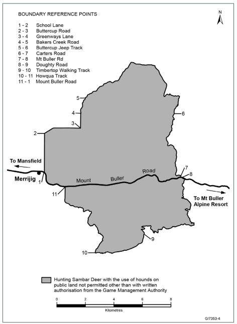
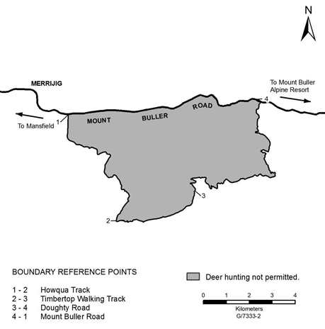
3. Merrijig, Mount Timbertop and surrounds closed to Sambar Deer hunting with hounds

4. Warburton Township closed to ALL forms of deer hunting

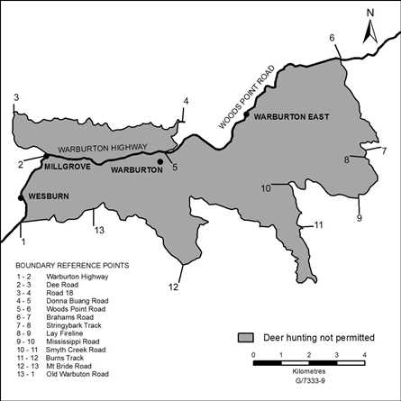
5. Area between Warburton, Noojee and McMahons Creek closed to ALL forms of deer hunting
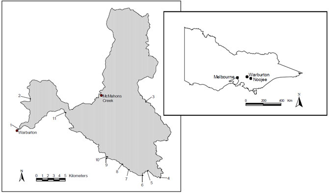
Image description: This image shows two maps. One map shows the Victorian state outline with Melbourne, Warburton and Noojee marked. Warburton is situated about 70 km north east of Melbourne. Noojee is situated approximately 25 km south east of Warburton. The second and main map is of the boundary around McMahons Creek and Warburton. Warburton is 15 km south west of McMahons creek. The boundary is irregularly shaped. It is two larger areas connected by a small narrow area. Of the 2 larger areas, the smaller one is to the north west of Warburton. the Largest area on the map is to the north, west and south of McMahons Creek. The boundary points, numbered 1 to 11 run in a clockwise direction, starting at point one at Warburton to point 11 which is 8 km north east of Warburton.
Boundary Reference Points
1-2 Acheron Way
2-3 Border of Yarra Ranges National Park
3-4 Boundary Road
4-5 McCarthy Creek Spur Road
5-6 Vehicular Track
6-7 Spur to Bennie Creek Reference Area
7-8 New Turkey Spur Track
8-9 Federal Short Cut Road
9-10 Big Creek Road
10-11 Braham Road
11-12 Warbutton - Wood Point Road
6. Area around Rubicon closed to ALL forms of deer hunting


Boundary Reference Points
1-2 100 metres from aqueduct
2-3 100 metres from pipeline
3-4 100 metres from Rubicon River
4-5 100 metres from aqueduct
5-6 100 metres from watercourse / dam
6-7 100 metres from aqueduct / tramway
7-8 100 metres from Royston River
8-9 100 metres from former tramway
9-10 100 metres from Royston River
10-1 Public land Boundary
7. Mount Timbertop Area closed to All forms of deer hunting

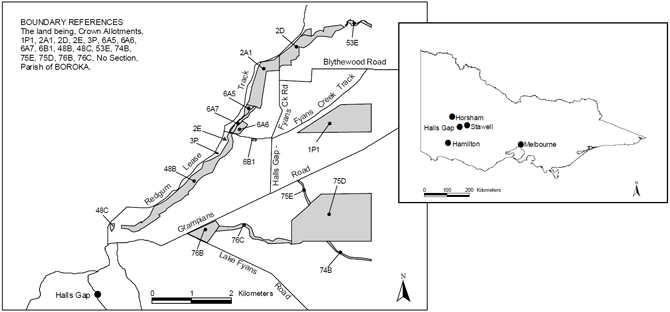
8. Areas around Halls Gap closed to ALL forms of deer hunting
Page last updated: 29 May 2026