Wetland closures
Check this page regularly for updates on wetland closures or the further regulation of hunting at wetlands during the 2026 duck season. Some wetlands may be added and others removed during the course of the season.
Closed or further regulated hunting areas
Occasionally, wetlands or parts of wetlands, may be closed to duck hunting or hunting may be further regulated (e.g. hunting from boats prohibited) to protect concentrations of rare or threatened species or breeding waterbird colonies from disturbance or being mistakenly shot.
Further regulation can involve additional restrictions on hunting times, equipment and hunting methods. If a closure is required, this can involve a partial closure of a hunting area or full closure.
Wetlands are monitored throughout the duck season. If the reason for further regulation or closure no longer exists, the wetland may be reopened to hunting.
Anyone can report sightings of threatened species and breeding waterbirds to the Department of Energy, Environment and Climate Action (DEECA) by completing a form on the Wildlife Victoria web page Duck season 2026.
These reports are then verified by staff from DEECA or the Game Management Authority and, where there are risks to significant concentrations of threatened species or breeding waterbirds, the wetland may be recommended for closure or further hunting regulation during the duck season. The Minister for Environment and the Minister for Outdoor Recreation are jointly responsible for enacting any wetland closures or further regulation via gazettal of a notice under the Wildlife Act 1975.
Hunting is not permitted in wildlife sanctuaries, including Reedy Lakes (Kerang), Kow Swamp (Gunbower) and Richardson River (Buloke Shire).
Wetlands closed or partially closed to hunting will be reflected in Victoria’s online hunting maps. Download the More to Explore app or visit MapshareVic.
Wetlands closed to hunting
The wetlands listed below will be closed or partially closed to duck hunting for the 2026 duck season or until reopened. Hunting from a boat will be prohibited at one wetland.
Check this page regularly for updates to this list. Some wetlands may be added and others removed during the course of the season.
Wetlands closed or partially closed to hunting will be reflected in Victoria’s online hunting maps. Download the More to Explore App or visit MapshareVic.
Table: 2026 duck season wetland closures as of Friday, 8 May 2026
See the Government Gazette notice.
Wetland name | Nearby town | Threatened species present / reason for closure | Regulation / Restriction |
|---|---|---|---|
| Green Lake, including Fresh Lake | Corop | Brolga | Entire wetland closed |
Lake Lonsdale | Stawell | Freckled Duck Blue-winged Shoveler Blue-billed Duck | Entire wetland closed |
Bradys Swamp State Game Reserve | Dunkeld | Brolga | Entire wetland closed |
Lake Wongan State Game Reserve | Streatham | Brolga Sharp-tailed Sandpiper | Entire wetland closed |
Lake Elingamite | Camperdown | Blue-winged Shoveler | Entire wetland closed |
Great Spectacle Lake | Kerang | Blue-winged Shoveler | Only the Great Spectacle Lake is closed (i.e. the other wetlands in the State Game Reserve remain open) |
Tower Hill State Game Reserve | Warrnambool | Blue-Winged Shoveler Blue-billed Duck | Entire wetland closed |
Lake Gnarpurt | Lismore | Blue-billed Duck | Hunting from boats prohibited. Hunting by wading permitted |
Nooramunga Marine & Coastal Park | Port Welshpool | Orange-bellied Parrot | Entire reserve closed |
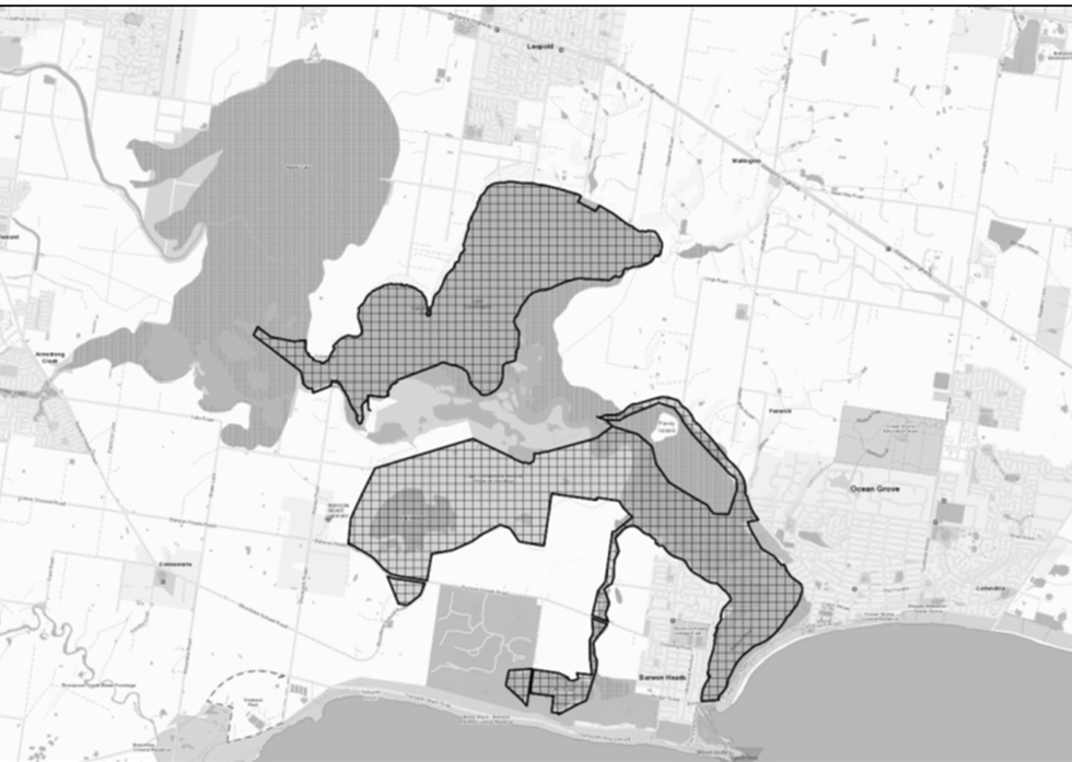
Lake Connewarre State Game Reserve (excluding Hospital Swamp and Reedy Lake) | Geelong | Orange-bellied Parrot | State Game Reserve is closed except Hospital Swamp and Reedy Lake which remain open to hunting. See map below. |
Anderson Inlet | Venus Bay | Orange-bellied Parrot | Entire reserve closed |
Sanctuaries | |||
Kow Swamp | Gunbower | N/A – closed to reaffirm wildlife sanctuary status | Entire reserve closed |
Reedy Lakes | Kerang | N/A – closed to reaffirm wildlife sanctuary status | Entire reserve closed |
Richardson River | Buloke Shire | N/A – closed to reaffirm wildlife sanctuary status | Entire reserve closed |
Lake Connewarre State Game Reserve partial closure
The whole of Lake Connewarre State Game Reserve, with the exception of Reedy Lake and Hospital Swamp, located in the City of Greater Geelong, north of Barwon Heads.
The eastern portion of the Lake Connewarre Wildlife Reserve, as shown by the hatching on the map below, located to the east of the line consisting of a straight line between 38° 12' 12" S, 144° 27' 8" E and 38° 13' 53" S, 144° 25' 26" E and a straight line between 38° 13' 53" S, 144° 25' 26" E and 38° 13' 54" S, 144° 25' 19" E, and a straight line between 38° 13' 54" S, 144° 25' 19" E and 38° 13' 52" S, 144° 25' 4" E, and a straight line between 38° 13' 52" S, 144° 25' 4" E and 38° 13' 46" S, 144° 24' 56" E, and a straight line between 38° 13' 46" S, 144° 24' 56" E and 38° 13' 51" S, 144° 24' 53" E, and a straight line between 38° 13' 51" S, 144° 24' 53" E and 38° 14' 9" S, 144° 25' 23 " E, and a straight line between 38° 14' 9" S, 144° 25' 23 " E and 38° 14' 17" S, 144° 25' 22" E, and a straight line between 38° 14' 17" S, 144° 25' 22" E and 38° 14' 26" S, 144° 25' 41" E, and a straight line between 38° 14' 26" S, 144° 25' 41" E and 38° 16' 43" S, 144° 25' 15" E.
Page last updated: 04 Jun 2026