Wetlands update – Dowd Morass to reopen to hunting and Green Lake and Fresh Lake to close
28/05/2026
The Victorian Government has announced that Dowd Morass State Game Reserve near Sale will reopen to duck hunting, and Green Lake, including Fresh Lake, near Corop will close to hunting from Sunday, 31 May 2026 (inclusive).
Thursday, 28 May 2026
The Victorian Government has announced that Dowd Morass State Game Reserve near Sale will reopen to duck hunting, and Green Lake, including Fresh Lake, near Corop will close to hunting from Sunday, 31 May 2026 (inclusive).
The south-eastern part of Dowd Morass has been closed since the beginning of the 2026 duck season to provide refuge to a breeding colony of protected Australasian Darters. Dowd Morass will now fully open to hunting as breeding has concluded and the young have left the nests.
Green Lake, including Fresh Lake, near Corop will be closed to hunting from this Sunday 31 May as recent surveys show significant numbers of endangered Brolga are routinely present at these adjacent wetlands.
Closing wetlands ensures that threatened species are protected and duck hunting remains sustainable. If the reason for closure no longer exists, wetlands may be reopened to hunting.
The Game Management Authority (GMA) and Department of Energy, Environment and Climate Action (DEECA) will continue to monitor wetlands across Victoria for the remainder of the season.
For details of wetlands closed or partially closed to hunting for the 2026 duck season, visit Wetland closures.
Hunters are reminded to check the GMA website for updates before they go hunting.
People are urged to report illegal hunting and breaches to public safety laws to the GMA online at Report illegal hunting or illegal protester activity or by calling 136 186.
The 2026 duck season will close 30 minutes after sunset on Monday, 8 June 2026. The daily bag limit is nine birds per day.
Wetlands update – Lake Cooper and Green Lake to reopen to hunting and Tower Hill to fully close
Tuesday, 5 May 2026
The Victorian Government has announced that Lake Cooper and Green Lake near Corop will reopen to hunting and the whole of Tower Hill State Game Reserve will be closed to duck hunting from Friday, 8 May 2026 (inclusive).
Lake Cooper near Corop has been closed since the beginning of the 2026 duck season due to the presence of significant numbers of threatened Blue-Winged Shoveler and Freckled Duck. Lake Cooper will reopen to hunting as many of the Blue-Winged Shoveler have left the wetland and the Freckled Duck are no longer present.
The adjacent Green Lake near Corop has also been closed to hunting since the beginning of the season due to a significant number of threatened Brolga. It will now reopen as Brolga numbers have declined to below threshold levels.
The western lake at Tower Hill State Game Reserve near Warrnambool has been closed to hunting since the beginning of the season due to the presence of a significant number of Blue-Winged Shoveler and Blue-billed Duck.
The whole of Tower Hill (western and eastern lakes) will be closed as recent surveys showed the number of Blue-Winged Shoveler has increased and they are present across the whole of the reserve.
Closing wetlands ensures that threatened species are protected and duck hunting remains sustainable. If the reason for closure no longer exists, wetlands may be reopened to hunting.
To see all wetlands closed or partially closed to hunting for the 2026 duck season, visit Wetland closures.
The Game Management Authority (GMA) and Department of Energy, Environment and Climate Action (DEECA) will continue to monitor wetlands across Victoria for the remainder of the season.
Hunters are reminded to check the GMA website regularly for updates before they go hunting.
People are urged to report illegal hunting and breaches to public safety laws to the GMA, online at Report illegal hunting or illegal protester activity or by calling 136 186.
The 2026 duck season will close 30 minutes after sunset on Monday, 8 June 2026. The daily bag limit is nine birds per day. Hunting of the Blue-winged Shoveler is prohibited.
Wetlands closed to hunting
Friday, 13 March 2026
The Victorian Government has closed 10 wetlands, partially closed two wetlands and prohibited hunting from boats at one wetland for the 2026 duck season to protect significant concentrations of threatened species or breeding waterbirds.
Closing wetlands or regulating hunting methods at wetlands ensures that threatened species are protected and duck hunting remains sustainable.
Hunters should check the GMA website before entering the field for the latest information on wetland closures.
If the reason for closure no longer exists, the wetland may be reopened to hunting.
Other wetlands may be closed or further regulated if significant concentrations of threatened species or breeding waterbirds are found.
An additional three waterbodies (Kow Swamp, Reedy Lakes and Richardson River) are routinely closed each year to reinforce their status as wildlife sanctuaries where game hunting is prohibited.
Hunters are reminded that the 2026 duck season opens at 8am on Wednesday, 18 March and closes 30 minutes after sunset on Monday, 8 June. Hunting start times are 8:00am until 30 minutes after sunset for the first five days (18 March – 22 March inclusive), then from 30 minutes before sunrise for the remainder of the season. Hunting finishes 30 minutes after sunset for every day of the season.
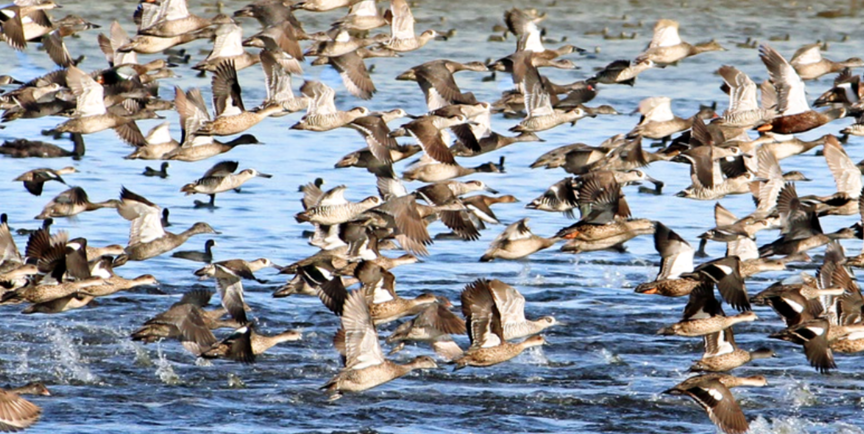
The daily bag limit is nine game ducks. Pacific Black Duck, Grey Teal, Chestnut Teal, Wood Duck, Mountain Duck, Hardhead and Pink-eared Duck may be hunted.
Hunters areresponsible for understanding their legal, ethical and safety obligations when hunting, including knowing where it is legal to hunt.
For information and maps showing where hunting is prohibited, including wetlands closed to hunting, download the More to Explore app or visit MapshareVic.
GMA Authorised Officers, Victoria Police and Authorised Officers from partner agencies will patrol wetlands across Victoria.
See wetland closures for more information.
See the Government Gazette notice.
The wetlands listed below will be closed or partially closed to duck hunting for the 2026 duck season or until reopened. Hunting from a boat will be prohibited at one wetland.
Check the Wetland closures page regularly for updates to this list. Some wetlands may be added and others removed during the course of the season.
Wetlands closed or partially closed to hunting will be reflected in Victoria’s online hunting maps. Download the More to Explore App or visit MapshareVic
Table: 2026 duck season wetland closures as of Wednesday, 18 March 2026
Wetland name | Nearby town | Threatened species present / reason for closure | Regulation / Restriction |
|---|---|---|---|
Lake Lonsdale | Stawell | Freckled Duck Blue-winged Shoveler Blue-billed Duck | Entire wetland closed |
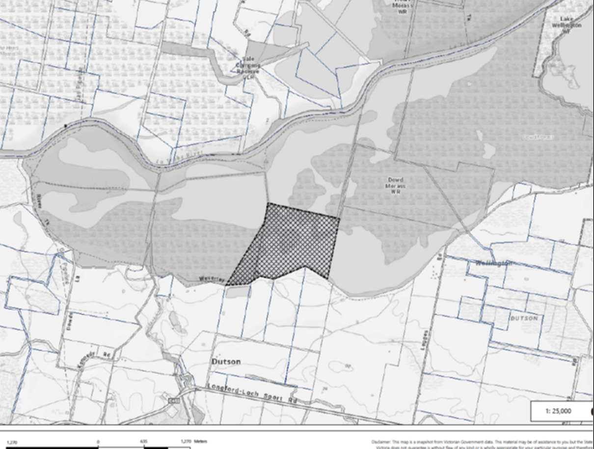
Dowd Morass State Game Reserve – South Central Portion | Sale | Breeding waterbirds | Wetland partially closed - only the area around the nesting colony is closed. See map below. |
Bradys Swamp State Game Reserve | Dunkeld | Brolga | Entire wetland closed |
Lake Wongan State Game Reserve | Streatham | Brolga Sharp-tailed Sandpiper | Entire wetland closed |
Lake Elingamite | Camperdown | Blue-winged Shoveler | Entire wetland closed |
Great Spectacle Lake | Kerang | Blue-winged Shoveler | Only the Great Spectacle Lake is closed (i.e. the other wetlands in the State Game Reserve remain open) |
Lake Cooper | Corop | Blue-winged Shoveler Freckled Duck | Entire wetland closed |
Green Lake (which includes adjacent Fresh Lake) | Corop | Brolga | Entire wetland closed |
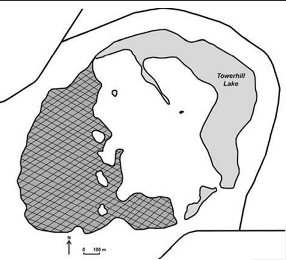
Tower Hill State Game Reserve – western lake only | Warrnambool | Blue-Winged Shoveler Blue-billed Duck | Partially closed - western lake closed, eastern lake open to hunting) See map below. |
Lake Gnarpurt | Lismore | Blue-billed Duck | Hunting from boats prohibited. Hunting by wading permitted |
Nooramunga Marine & Coastal Park | Port Welshpool | Orange-bellied Parrot | Entire reserve closed |
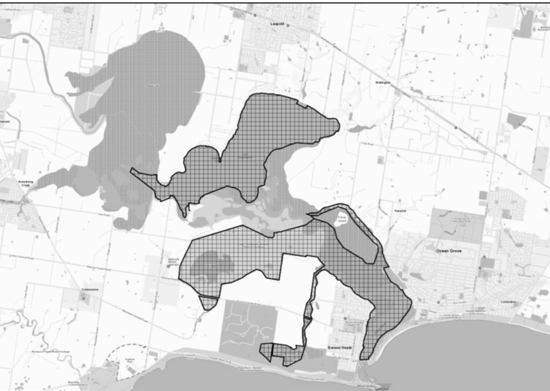
Lake Connewarre State Game Reserve (excluding Hospital Swamp and Reedy Lake) | Geelong | Orange-bellied Parrot | State Game Reserve is closed except Hospital Swamp and Reedy Lake which remain open to hunting. See map below. |
Anderson Inlet | Venus Bay | Orange-bellied Parrot | Entire reserve closed |
Sanctuaries | |||
Kow Swamp | Gunbower | N/A – closed to reaffirm wildlife sanctuary status | Entire reserve closed |
Reedy Lakes | Kerang | N/A – closed to reaffirm wildlife sanctuary status | Entire reserve closed |
Richardson River | Buloke Shire | N/A – closed to reaffirm wildlife sanctuary status | Entire reserve closed |
Tower Hill State Game Reserve partial closure
The western lake of Tower Hill State Game Reserve, as shown by the hatching on the map below, located in the Warrnambool City, north-west of Warrnambool. The northern point of closure is the line between 38o18’29.17”S, 142o21’14.38”E and 38o18’38.92”S, 1425o21’14.38”E.
Dowd Morass State Game Reserve partial closure
A south-central portion of the Dowd Morass State Game Reserve to be closed to hunting, as shown by the hatching on the map below, the Western boundary of which being a straight line between 38.159316o S, 147.176385 o E and 38.151584 o S, 147.182049 o E and a straight line between 38.151584 o S, 147.182049 o E and 38.148996 o S, 147.182744 o E, the Northern boundary being a straight line between 38.148996 o S, 147.182744 o E and 38.150699 o S, 147.194024 o E, the Eastern boundary being a straight line between 38.150699 o S, 147.194024 o E and 38.158288 o S, 147.192298 o E and the Southern boundary being the southern boundary of Dowd Morass State Game Reserve between 38.158288 o S, 147.192298 o E and 38.159316 o S, 147.176385 o E.
Lake Connewarre State Game Reserve partial closure
The whole of Lake Connewarre State Game Reserve, with the exception of Reedy Lake and Hospital Swamp, located in the City of Greater Geelong, north of Barwon Heads.
The eastern portion of the Lake Connewarre Wildlife Reserve, as shown by the hatching on the map below, located to the east of the line consisting of a straight line between 38° 12' 12" S, 144° 27' 8" E and 38° 13' 53" S, 144° 25' 26" E and a straight line between 38° 13' 53" S, 144° 25' 26" E and 38° 13' 54" S, 144° 25' 19" E, and a straight line between 38° 13' 54" S, 144° 25' 19" E and 38° 13' 52" S, 144° 25' 4" E, and a straight line between 38° 13' 52" S, 144° 25' 4" E and 38° 13' 46" S, 144° 24' 56" E, and a straight line between 38° 13' 46" S, 144° 24' 56" E and 38° 13' 51" S, 144° 24' 53" E, and a straight line between 38° 13' 51" S, 144° 24' 53" E and 38° 14' 9" S, 144° 25' 23 " E, and a straight line between 38° 14' 9" S, 144° 25' 23 " E and 38° 14' 17" S, 144° 25' 22" E, and a straight line between 38° 14' 17" S, 144° 25' 22" E and 38° 14' 26" S, 144° 25' 41" E, and a straight line between 38° 14' 26" S, 144° 25' 41" E and 38° 16' 43" S, 144° 25' 15" E.